World Travel Explorer: Nature Tourism World Travel Explorer: Nature Tourism

11 FREE TRAVEL DESTINATION IN JAKARTA

Free tours in Jakarta that are comfortable and enjoyable for those of you who want to vacation around the city of Jakarta

BANYU TIBO BEACH, PACITAN

Banyu Tibo Beach is a beach tourism object that presents quite beautiful natural panoramas that are rarely found on beaches in Indonesia.

Pindul Gunung Kidul Cave Nature Tourism

Enjoy Nature with Cave Tubing

INDRAYANTI BEACH GUNUNGKIDUL

Jogja Beach Tourism with Balinese Nuances

NAMPU BEACH

Nampu Beach, Exotic Wonogiri Beach Tourism

HISTORY OF MATHEMATICS

The branch of study known as the history of mathematics is the investigation of the origins of discoveries in mathematics and, to a lesser extent, the investigation of the methods and notation of mathematics in the past

HISTORY OF MOUNT KRAKATAU IN INDONESIA

In the beginning, the big island of Krakatau, which we usually call by the name of Mount Krakatau, was a mountain (ancient Mount Krakatau) which has a height of about 2000 meters above sea level with a circle of beaches of about 11 km and a radius of about 9 km2.

Showing posts with label Nature Tourism. Show all posts

November 16, 2025

Mount Inerie, the Volcanic Pyramid of East Flores

Mount Inerie, the Volcanic Pyramid of East Flores
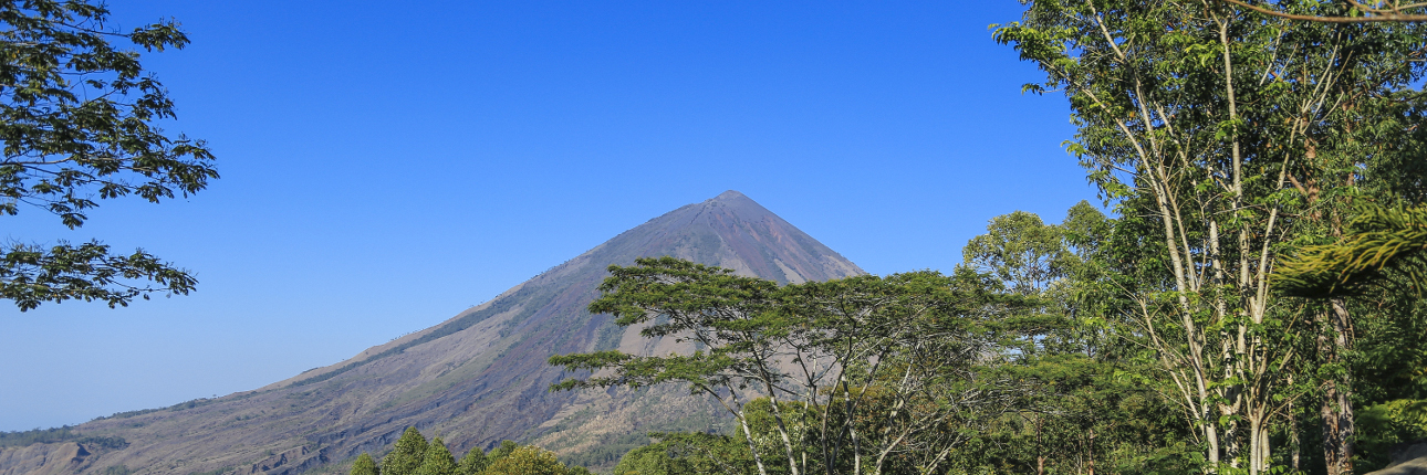
Located in Flores, East Nusa Tenggara, this mountain attracts climbers thanks to its iconic pyramid shape and its status as an active volcano.
Mount Inerie, the Volcanic Pyramid of East Flores

While Mount Sadahurip in Garut, West Java, is known for its pyramid-like shape, on Flores Island, East Nusa Tenggara, Mount Inerie is no less captivating. This mountain is located in Ngada Regency, approximately fifteen kilometers south of Bajawa, the regency's capital. With its pointed, symmetrical peak, Mount Inerie presents a majestic silhouette reminiscent of ancient Egyptian pyramids.

The beauty of this still-active volcano can be enjoyed from various vantage points. Aimere and Manulalu Inn are two favorite spots to view Mount Inerie in its entirety. From these vantage points, the pyramidal silhouette of the mountain, which last erupted in 1970, is most clearly visible, especially when the sky is clear and the sun shines on its slopes.
Mount Inerie, the Volcanic Pyramid of East Flores
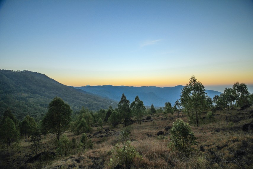
"Even though this mountain rises to 2,245 meters above sea level, the journey time to the summit is relatively short—about three to five hours."

For those seeking a more intimate experience, climbing Mount Inerie can be an unforgettable option. Although the mountain rises 2,245 meters above sea level, the journey to the summit is relatively short—around three to five hours. This is because the hiking trail begins from Watumeze Village, which is already located on a plateau. Climbers usually begin early in the morning to reach the summit in time for sunrise, offering stunning views that are well worth the effort. Mount Inerie is most visited during the dry season, between June and August, when the weather is more favorable and the hiking trail is in optimal condition.

However, climbing Mount Inerie is not easy. The hiking trail is dominated by gravel and rocks all the way to the summit, making the terrain slippery and difficult to walk on. In some sections, climbers may even have to crawl to continue ascending. The lack of vegetation along the trail also poses a challenge, especially if climbing during the day when the sun is directly blazing without shade.
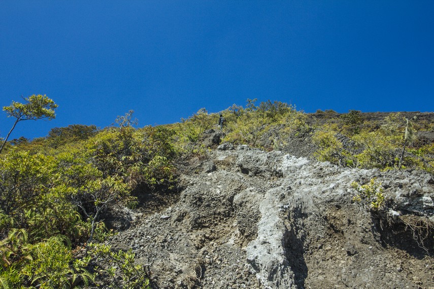
"The climbing route is dominated by gravel and rocky terrain all the way to the summit, making the terrain slippery and difficult to walk on."
Mount Inerie, the Volcanic Pyramid of East Flores

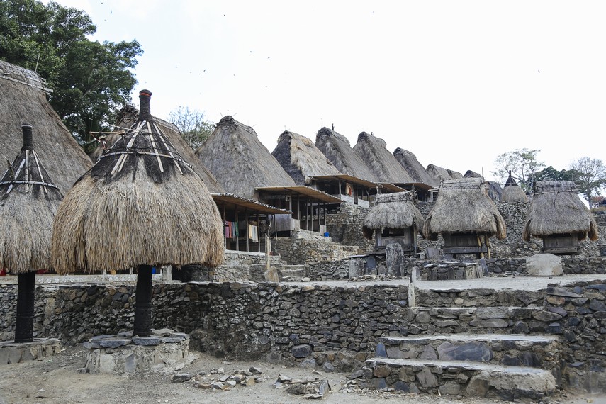
After traversing quite challenging terrain, climbers will reach the first ridge. From this point, the deep crater of Mount Inerie begins to appear. However, the journey is not over. Rocky terrain and increasingly steep slopes remain to reach the highest peak. After about 30 minutes of climbing from the final ridge, climbers will finally reach the summit, marked by three cross-shaped poles embedded in the ground. From this point, the Bena Traditional Village—located right at the foot of the mountain—can be clearly seen and is a unique attraction in Ngada Regency.
Mount Inerie, the Volcanic Pyramid of East Flores

Climbing Mount Inerie is well-known among both local and international tourists. For further information or guide services, a tourist information center in Bajawa City is available to assist visitors.

Mount Inerie, the Volcanic Pyramid of East Flores

December 12, 2015

Gunungkidul Pindul Cave Nature Tourism, Enjoy Nature with Cave Tubing

Gunungkidul Pindul Cave Tourism: Enjoy Nature with Cave Tubing

Pindul Cave Tourism Object Gunungkidul - Pindul Cave which is located in the hamlet of Titleran I, Bejiharjo Village, Karangmojo District, Gunung Kidul, about 7 km to the north of Wonosari City, is one of seven caves fed by an underground river in the Beriharjo area. The Pindul Cave Tourism Object has a water depth of about 5 meters, a length of about 300 meters, and a width of 5 meters, and the distance between the roof of the cave and the water surface is about 4 meters.

In one part of Pindul Cave, precisely in the middle of the cave, there is a rather large room with a hole on top, the people around the cave call it an inverted well, and the atmosphere is even more impressive with the beautiful natural panorama with sunlight entering this room. This hole is often used as a vertical entrance by members of the Sar Team or by visitors to Pindul Cave Tourism.
Gunungkidul Pindul Cave Tourism: Enjoy Nature with Cave Tubing

History of Pindul Cave
According to stories circulating in the surrounding community, it all started with a character named Kyai Jaluwesi who had a conflict with a giant named Bendhogrowong. The two of them were involved in fighting supernatural powers, with Kyai Jaluwesi excelling. The giant then issued his knowledge due to feeling pressured. Unfortunately, the knowledge went wrong about Widodo and Widadi's pet dog, Kyai Jaluwesi's twins. The dog, named Sona Langking, was seriously injured and ran wildly toward a water source that was behind the bushes. Kyai Jaluwesi, who followed Sona Langking's running direction, was shocked when he found that his dog had recovered from a serious injury caused by the giant's magic.

Seeing this, Kyai Jaluwesi then named the water source Mbelik Panguripan, because it was able to heal the severe injuries his dog had suffered. Sometime after that incident, a man and woman named Kyai and Nyai Sejati appeared who wanted to rule over the land around Mount Bang. They asked Kyai Jaluwesi to move from that place, and Kyai Jaluwesi agreed. Even so, Kyai Jaluwesi wanted a condition, that is, after his move, the people of Gunung Bang had to hold a clean lepen (river) event, ledhek (tayub) dancers, on Monday Most every year. Then Kyai Jaluwesi moved to the Pindul Cave area, until moksa, and is believed to be a caretaker at Pindul Cave and Mbelik Panguripan.

Of course, legends or stories circulating cannot be trusted one hundred percent, but a good reader should be able to understand what is behind each legend, not even consider it mystical or unreasonable. The Gunungkidul Pindul Cave Tourism Object, which is currently the prima donna of cave tubing tourism, is indeed very interesting and offers a different sensation from other tours that are common in Yogyakarta.

Cave Tubing Sensation
Cave tubing is almost the same as rafting (rafting). If rafting or white water rafting is an activity along a river using a boat, then cave tubing is an activity along a cave by riding on an inner tube. Because the flow of water in the Pindul Cave Nature Tourism Object is calm and the water discharge is relatively the same both in the rainy season and the dry season, cavetubing in Pindul Cave can also be done by beginners or small children.

When you go exploring in Pindul Cave, you will find a stalactite that has merged with a stalagmite so that it looks like a pillar with the width of five adult arms (Soko Guru). This stalactite is the largest in Pindul Cave and is ranked number 4 in the world.

Facilities at the Pindul Cave Tourism Object
Cave tubing tours in Pindul Cave provide guides who can guide us to cave tubing. The manager has provided cave tubing equipment such as tires and life vests, as well as headlamps. To rent these facilities, visitors will be charged a fee of around IDR.25,000 - IDR.30,000.

February 01, 2015

Ciwidey White Crater Nature Tourism, Bandung

Ciwidey White Crater
Ciwidey White Crater Tourism Object - Ciwidey White Crater is one of the most famous tourist attractions in Bandung, with stunning natural panoramas that make this Ciwidey White Crater tourist area have its own charm to visit.

Ciwidey white crater which is located on Jl. Raya Soreang Ciwidey 25 km from Bandung Regency, West Java. Access to the white crater tourist spot is fairly easy and can be reached by using public transportation or by private vehicle.

Kawah Putih is a volcanic lake formed from the eruption of Mount Patuha which has a height of 2,434 meters above sea level. Even though it is a volcanic crater, the White Crater can be reached directly by tourists, because currently Mount Patuha has been declared no longer active. The natural charm presented by Kawah Putih is so beautiful that Nature Tourism is so crowded with visitors, many young couples choose Kawah Putih as a suitable place to do pre-wedding photo shoots.
Ciwidey White Crater

To get to the White Crater Nature Tourism, visitors must travel up the mountain, about 3 Km from the entrance gate. For those of you who bring a private vehicle, you can choose to park in the lower area and use the traditional "ontang-anting" vehicle provided by the tour operator to go up to the white crater location. However, you can also use your car to go upstairs and park your vehicle in the upper parking area. For those of you who have never been to Kawah Putih, don't forget to bring a jacket or thick sweater, because the temperature in this area is quite cold. To avoid the pungent smell of sulfur, you are advised to wear a mask. If you forget to bring one, don't worry. Before entering, many people sell masks to visitors.

Before entering the crater area, visitors must go down several stairs. From the height of the stairs, you can already see the natural beauty of Kawah Putih and the occasional smell of sulfur. If the weather is rainy, the crater steam can rise up and cover the crater area so that it looks like fog. At that time it is recommended not to linger in the crater area because the gas and pungent smell of sulfur can be harmful to health. In addition, in the crater area, there is a cave, which is called the Dutch Cave. This cave has been closed, so visitors can only see the mouth of the cave which has been sealed with boards by the tour manager.

History of Ciwidey White Crater

Behind the beautiful scenery of Kawah Putih, it turns out that this tourist spot was previously considered a haunted place by the local community. Mount Patuha by the local community is also called Mount Sepuh. The name Patuha itself comes from the word Old Man. It is said that according to local stories, on Mount Patuha there are ancestral graves, and is a meeting place for ancestors. So that the local people did not dare to enter the crater area at that time. Finally, in 1837, a German botanist, Franz Wilhelm Junghun, made observations of Mount Patuha and found a very beautiful volcanic lake which is now known as Kawah Putih.

This is a glimpse of Ciwidey White Crater, all information about this tourist attraction is summarized from various sources, hopefully, it can be a reference for you to get to know more closely the Enchantment of Natural Beauty of Ciwidey White Crater, which is Exotic. Thank you for visiting and have a nice visit.

January 31, 2015

Natural Panoramic of Setren Wonogiri Waterfall Tourism

Setren Waterfall

The Setren Waterfall Tourism Object, which is located in Slogohimo District, approximately 30 Km east of Wonogiri City, has a natural panorama that is no less interesting than the Tawangmangu waterfall. The unspoiled natural scenery of Setren Waterfall with panoramic views of the hills and waterfalls is the main attraction to be enjoyed.

Slogohimo sub-district is one of the mainstay sub-districts producing regional original income (PAD) Wonogiri. Especially if judging from the geographical location, the Slogohimo area is a fairly busy intersection area. If you go east, you will go to the Purwantoro District area which is the border area with East Java, while if you go south you will also penetrate East Java.

The natural potential of the mountains is a source of domestic foreign exchange, namely the Girimanik waterfall in Setren Village. This area can be said to be similar to the Tawangmangu area, Karanganyar, only the Setren area is not well known by the wider community. However, judging from the natural conditions, the beauty and coolness are almost the same as in the Tawangmangu area, Karanganyar.

Since 2000, the Government of Wonogiri Regency has tried to develop nature tourism in the Girimanik waterfall mountains. The natural wealth of the mountains is one of the mainstays of the Slogohimo area. In fact, the Wonogiri Regency Government also has high hopes for the Girimanik mountain area. The reason is that if the Girimanik mountain area is developed optimally, it will be able to generate local revenue.

Apart from Setren Waterfall, in the Girimanik mountains, there is also spiritual tourism, so in the Wonogiri area, spiritual tourism can be found in Tirtomoyo, Paranggupito, and Slogohimo sub-districts.

In Girimanik nature tourism, there are three waterfalls, namely Manikmoyo waterfall, Condromoyo waterfall, and Tejomoyo waterfall. The physical attraction in the form of beautiful and natural mountain scenery makes this waterfall a mainstay of tourism development.

Every year, the traditional ceremony of Susuk Wangan is held at Setren, which is a thanksgiving ceremony for Setren residents for the crops they have achieved. During the Susuk Wangan ceremony, tourist visitors can see hundreds of roasted chickens offered by the farmers to the Creator.
In addition, the Donoloyo forest, which is overgrown with large teak trees, is one of the potentials developed by the Slogohimo District. Apart from that, the Slogohimo sub-district is also known by the community as a producer of durian fruit. Durian fruit from Slogohimo is often sent to Jakarta or other big cities. Moreover, the durian fruit from Slogohimo has its own taste. Durian fruit has great potential and is suitable for development in the Slogohimo area

The four central durian villages are Slogohimo, Sedaya, Gunan, and Sokoboyo villages. To support agribusiness, Setren Village will also develop durian plants. The Wonogiri Agriculture Service has provided assistance to as many as 400 durian seedlings to be developed at Setren.

Thus a review of Setren Waterfall, all information about this tourist attraction is summarized from various sources, hopefully, it can be a reference for you to get to know more about the enchanting beauty of Setren Waterfall, Wonogiri. Hope it is useful

January 30, 2015

The exoticism of Sri Gethuk South Mountain Waterfall

Sri Gethuk South Mountain Waterfall

Sri Gethuk Waterfall Tourism Object - Located between the Oya river gorge and surrounded by green rice fields, makes the Natural Enchantment of Sri Gethuk Waterfall is even more interesting to enjoy. This waterfall, which is located in Padukuhan Menggoran, Bleberan Village, Player District, South Mountain Regency, Yogyakarta, is a waterfall that does not originate from the main river. Precisely Srigethuk Waterfall divides the Oya river cliffs and merges into the same flow, so it is not surprising that there is an atmosphere of contrast. The waterfall is so clear, while the Oya river water is cloudy. An interesting combination to be enjoyed. Sri Gethuk Waterfall always flows regardless of the season. Its roar broke the silence on the dry land of South Mountain.

Sri Gethuk Waterfall
Getting to the tourist location of Sri gethuk Waterfall is not difficult. There are many signposts that will lead you to the location. After the Gading airport, you just have to turn right. After the Player market, there is a T-junction with a sign to the right. Follow the road and pay attention to the signposts. The village's smooth roads seem to take off the image of South Mountain, which is all deprived.

This atmosphere is completely different from the situation two years ago. The cobbled streets have been replaced with paved roads. The road to the location has also been made circular past the Rancang Kencono cave. This rocky ring road passes through beautiful natural scenery with a stretch of the moor. This ring road is made to make it easier for visitors so they don't get stuck in traffic jams when the flow of visitors is booming.

Srigethuk Waterfall
Stalls selling various typical South Mountain dishes are lined up neatly to the river's edge. Bathroom facilities and changing rooms are also available in the parking area.

In the past, there was only one gethek serving. Now, I see that there are three getheks who are ready to accompany tourists who will enjoy the beauty of Srigethuk. The tourists who use the services of this gethek have to spend ten thousand to go back and forth. If you want a bit of a challenge, you can go to the location on foot through the rice fields and fields.

enjoy the beauty of Srigethuk
Entering the Sri Gethuk Waterfall Tourism area, there is such a mystical aura. The strength of this aura is further strengthened by the circulation of myths that exist and develop in society. Sri Gethuk is the name given to this waterfall. This name comes from a gamelan musical instrument, namely kethuk. It is said that it was at this location that the genie Uango Menduro kept the kethuk. Over time and to make it easier to pronounce, the kethuk pronunciation changes to gethuk. Be the name of Sri Gethuk. So, the name gethuk has nothing to do with the name of one of South Mountain's specialties.

Thus a brief review of Srigethuk South Mountain Waterfall, all information regarding this exotic tourist object is summarized from various sources. I hope this can be a reference for you to get to know more about the Enchantment of the Beauty of the Sri Gethuk Gunungkidul Waterfall Tourism Object. Hope it is useful.

January 25, 2015

Kencono Design Cave

Kencono Design Cave

Rancang Kencono Cave Tourism Object - Rancang Kencono Cave is a cave tourism object located in Player District, Gunugkidul Regency, Yogyakarta. This tourist object is not very well known, but actually, this cave is located in an area with a fairly well-known tourist destination, namely Sri Gethuk Waterfall.

History of Design Kencono Cave

Gunungkidul Regency is one of the areas included in the Karst Region of the Sewu Mountains with a unique natural panorama. In addition to phenomena on the surface (eksokarst) in the form of karst hills, in Gunungkidul Regency there are also phenomena below the surface (endokarst) in the form of underground rivers, valleys, lakes, luweng, and caves. Because it's not surprising that Gunungkidul has many caves scattered in the bowels of the earth. One of the caves that anyone can enter without special equipment is the Rancang Kencono Cave which is located in Bleberan Tourism Village, Gunung Kidul Regency.

Kencono Design Cave

Based on the book "Mozaik Pusaka Budaya Yogyakarta" compiled by the Yogyakarta Archaeological Heritage Preservation Center, the Rancang Kencono Cave is an ancient cave parallel to the Braholo Cave located in Rongkop District, this is based on the discovery of artifacts and bones that are thought to have lived thousands of years ago. The cave, which has a large and airy room with klumpit trees which are estimated to be more than 2 centuries old, was once used as a hiding place and meeting place for the Mataram Warriors when they were planning to expel the Dutch from the Ngayogyakarta Hadiningrat Sultanate. Because it is used to design strategies for noble goals, this cave is called the Rancang Kencono Cave.

To enter Rancang Kencono Cave Nature Tourism, it is enough to go down the stone steps that have been built long ago. A klumpit tree whose height exceeded the roof of the cave greeted him gallantly. Large holes due to weathering are seen in tree trunks to indicate old age. Rancang Kencono Cave has a large courtyard or room that can be used to hold meetings. Stalactites appear to adorn the ceiling of the cave, many of which are dead so that no more dripping water can be seen. Next to the large room, there is a small room and narrow and pitch black. To enter this room must pass through a small gap by ducking. Inside this narrow space, there is a painting of the red and white flag and words of encouragement addressed to the fighters.

Apart from the narrow and dark niches of the cave, on the other side, there is also a passage that is said to connect Rancang Kencono Cave with Sri Gethuk Waterfall. When entering the hall, you have to walk crouching and even crawl occasionally because the ceiling is very short. According to the manager, some of the passages have collapsed so they cannot be tracked. As night approaches, the Rancang Kencono Cave, which is illuminated by the faint moonlight, looks both mystical and exotic.

That's a glimpse of the Rancang Kencono Cave, all information about this tourist attraction is summarized from various sources. I hope this short review can be a reference for you to get to know more about the beauty of the Exotic Rancang Kencono Cave. Hope it is useful.


Natural Panorama of Komodo Island National Park

Natural Panorama of Komodo Island National Park

Komodo Island Tourism Object - Komodo Island is an island located in the Nusa Tenggara Islands. Komodo Island is known as the original habitat of Komodo dragons. Komodo Island is also part of the Komodo Island National Park which is managed by the Central Government. Komodo Island is to the east of Sumbawa Island, which is separated by the Sape Strait.

Natural Panorama of Komodo Island National Park

Administratively, this island belongs to the Komodo District, West Manggarai Regency, East Nusa Tenggara Province, Indonesia. Komodo Island is the westernmost tip of East Nusa Tenggara Province, bordering West Nusa Tenggara Province.

In Komodo Island National Park, Komodo dragons live and breed well. Until August 2009, on this island, there are about 1300 dragons. Coupled with other islands, such as Rinca Island and Gili Motang, their total number reaches around 2500 individuals. There are also around 100 Komodo dragons in the Wae Wuul Nature Reserve on the mainland of Flores Island but not including the Komodo National Park area.

Natural Panorama of Komodo Island National Park
Apart from Komodo dragons, this island also has a variety of exotic flora, the Sepang tree which is used by local residents as medicine and clothing dye, nitak tree (sterculia oblongata) is believed to be useful as medicine and its seeds are tasty and delicious like peas.

Komodo Island is very impressive, exploring exotic islands, diving into the blue sea, and being bathed in sunlight while seeing traces of past life that have been preserved and will become part of the variety of beauty of Indonesia.

In fact, the attraction of Komodo National Park is not solely due to the mere presence of Komodo dragons. As quoted from the official website of the Ministry of Forestry which manages the Komodo National Park site, panoramic savanna, and underwater views are potential supporting attractions. Marine tourism, for example, fishing, snorkeling, diving, canoeing, canoeing. Meanwhile, on the mainland, the potential for natural tourism can be done is observing animals, hiking, and camping. Visiting Komodo National Park and enjoying the captivating natural scenery is an experience that will never be forgotten.

History of Komodo Island National Park

In 1910 the Dutch named the island on the south side of East Nusa Tenggara Province with the nickname Komodo Island. This story begins with Lieutenant Steyn van Hens Broek who tries to prove reports by Dutch troops about the presence of a large animal resembling a dragon on the island. Steyn then killed the Komodo dragon and took the documentation to the Museum and Botanical Garden in Bogor for research.

In 2009, Komodo National Park was named a finalist for the "New Seven Wonders of Nature" which was just announced in 2010 through online voting at www.N7W.com. Komodo was included in the list of winners along with the Amazon Forest, Halong Bay, Iguazu Falls, Jeju Island, Puerto Princesa Underground River, and Table Mountain. Komodo National Park gets the most votes.

Thus a brief review of the Komodo Island Tourism Object Area, all information regarding this tourist attraction is summarized from various sources. I hope this can be a reference for you to get to know more about the Enchantment of the Beauty of the Komodo Island National Region. Hope it is useful.

January 17, 2015

Sangeh Bali Nature Tourism

Sangeh Bali Nature Tourism
Sangeh Nature Tourism - Sangeh Natural Tourism Park is one of the tourist objects on the island of Bali. Even though Sangeh is not as famous as Kuta Beach, Tanah Lot, or other tourist attractions in Bali, this Sangeh tourist park also has its own charm for visiting tourists. The location of the Sangeh Tourism Object is only about 20 km from Denpasar.

One of the charms of the Sangeh Bali Nature Park is forest tourism in which there are lots of monkeys that inhabit the Sangeh forest area. To visit Sangeh, visitors should be more careful, because the monkeys in Sangeh are famous for their pranks, such as taking visitors' luggage, and will return it if visitors give them their favorite food such as bananas, nuts, or other foods.

Sangeh Bali Nature Tourism
What's interesting about the monkeys that live in Sangeh Nature Tourism is that they also have several groups, and each group has one leader. But these groups still have the highest leader or king of all the monkey kings in Sangeh. The highest minister resided in the most spacious place. Where this monkey king lives, there is a temple that is very famous for its sacredness, namely Pura Bulit Sari.

Like humans when they want to choose a candidate for their leader, the monkeys also choose the chosen monkey who is considered to have above-average charisma and strength. These leaders have rights that exceed other monkeys, especially in marrying female monkeys or in food rations. Usually, the monkey who is the elder or considered the king of the monkeys will be given the opportunity to get food until he is satisfied, only when he is satisfied, the rest is given to other monkeys.

According to the management of this tourist park, the Sangeng Tourism Forest was created as a park for the Mengwi kingdom. To make this garden look beautiful, nutmeg trees are specially imported from Mount Agung. Actually, the plan for making this park was very secret, but in the end, the construction of this park was discovered by several people, as a result, the construction of the park was stopped, so that finally the area was named Sangeh, which means that there were people who saw it.

Sangeh is located 20 km north of Denpasar, across the road to Pelaga. Apart from monkeys, the attraction of this tourist attraction is the temple which is located in the middle of a nutmeg tree called Bukit Sari Temple. The nutmeg tree forest is a sacred temple area that is sacred to the people of the Sangeh Traditional Village.

As mentioned above, Sangeh Nature Park is located in Sangeh Village, Badung, Bali, about 20 km north of Denpasar, across the road to Pelaga. which has the attraction of this tourist attraction is the temple which is located in the middle of a nutmeg tree called Bukit Sari Temple.

The nutmeg tree forest is a sacred temple area that is sacred to the people of the Sangeh Traditional Village. In the middle of a dense green forest, there are many tame monkeys that often fascinate tourists.
Sangeh Bali Nature Tourism
Apart from the nutmeg tree, there are still plants that are famous in the Sangeh forest. The local people usually call it the Lanang Wadon Tree, because the bottom of the tree is hollow so that it resembles female genitalia, while in the middle of the hole grows a stem that points downwards which looks like male genitalia. The tree grows right in the front yard of the Sangeh tourist spot and is actually a pule tree.

In Bali, the pule tree has many features because its wood is often used for special purposes, for example, to make masks used as breech.

December 20, 2014

Enjoy the Enchantment of the Beauty of Maharani Lamongan Cave

Enjoy the Enchantment of the Beauty of Maharani Lamongan Cave
Maharani Cave Tourism Object - Maharani Cave is a natural tourist object located in Paciran District, Lamongan Regency, East Java. Maharani Cave was first discovered accidentally in 1992 and was inaugurated as a tourist attraction on March 10, 1994, by the Regent of Lamongan. This cave, which is also known as the Maharani Palace cave, is located at a depth of 25 m from the ground with a cave cavity of 2500 m2.

In the Maharani Cave Tourism Area, there are various facilities as supporting facilities for visitors to the Maharani Cave tourism objects such as places of worship, health clinics, public toilets, large parking areas, as well as food vendors and souvenir shops that provide unique souvenirs so that this facility makes visitors to the Maharani Cave Tourism Object more comfortable.

When you enter the Maharani Cave tour, you will be spoiled with a truly amazing sight inside the Maharani Cave, namely the stalactites and stalagmites that emit such beautiful colorful rays. This is what makes tours to Maharani Cave different from other caves.

To get to the location of the Maharani Cave Tourism Object Area, you can access it from the city of Surabaya and Tuban Regency to Lamongan because the location of Maharani Cave is located on the side of the road crossing from Gresik to Tuban. This tourist attraction is open from 07.30 to 12.30 and reopens from 13.00 to 17.00 and is open every day to the public. The distance taken from Surabaya to Lamongan is approximately 60 km or about 1.5 hours drive by public transportation or private vehicle. Meanwhile, from Tuban Regency, it is about 30 km or about half an hour by private or public transportation to get to Lamongan.

This is a glimpse of Maharani Cave Tourism, all information about this tourist attraction is summarized from various sources. Hopefully, this brief review can be a reference for you to get to know more about the Enchantment of the Beauty of Maharani Lamongan Cave. Hope it is useful and thanks for visiting.

December 18, 2014

Enchantment of the Natural Beauty of the Exotic Ijen Crater

Enchantment of the Natural Beauty of the Exotic Ijen Crater
Ijen Crater Tourism Object - Ijen Crater is a crater lake which is located at the top of Mount Ijen at an altitude of 2368 meters above sea level with a lake depth of up to 200 meters and an area of ​​5466 hectares. The Ijen Crater Tourism Object Area or the Ijen Tourism Park Nature Reserve is located in the Licin District, Banyuwangi Regency, and Klobang District, Bondowoso Regency.

Ijen Crater is one of the most acidic craters in the world with an acidity level close to zero that can melt the human body. However, behind the level of acidity in this dangerous crater, there is the Enchantment of the Beauty of the Ijen Crater which is so enchanting with turquoise green sulfur.

Enchantment of the Natural Beauty of the Exotic Ijen Crater
Apart from that, in the tourist area of ​​Mount Ijen, there is also sulfur mining, which indicates that this mountain is still active. While at the location of the Ijen Crater Tourism area, visitors can witness miners who are busy carrying piles of sulfur on their backs along a steep road filled with dangerous poison gas.

Access to the Location of the Ijen Crater Tourism Area
To get to the Mount Ijen Tourism Location, it can be accessed from two directions, namely, from the north and from the south. If you are from the north, you can go via Situbondo to Sempol (Bondowoso) via Wonosari and continue to Paltuding. The distance from Situbondo to Paltuding is about 93 Km and can be reached in about 2.5 hours.

Meanwhile, if you are from the south, you can go from Banyuwangi to Licin which is 15 Km away. From Licin to Paltuding it is 18 Km and continues using a Jeep or other heavy car for about 6 Km before going to Paltuding. This is because the road is winding uphill.

That's a glimpse of Ijen Crater, all information about this exotic crater is summarized from various sources. Hopefully, this brief review can be a reference for you to learn more about the Enchantment of the Natural Beauty of Ijen Banyuwangi Crater. Hope it is useful and thanks for visiting.

October 26, 2014

West Java Cukang Taneuh Tourism Object

West Java Cukang Taneuh Tourism Object

West Java Cukang Taneuh Tourism Object - Cukang Taneuh or Green Canyon is a natural tourist object located in Kertayasa Village, Cijulang District, Ciamis Regency, West Java. This amazing tourist object is actually a stream from the Cijulang river that passes through a cave full of beautiful stalactite and stalagmite charms.

In addition, Cukang Taneuh Nature Tourism is flanked by two towering rocky hills with a grove of trees which makes this natural tour so exotic with the scent of nature that is still virgin.

West Java Cukang Taneuh Tourism Object
To reach the Cukang Taneuh Natural Tourism Object, visitors must rent a rowboat from the Ciseureuh pier. The trip takes approximately 30-45 minutes with a distance of about 3 km to get to Green Canyon Nature Tourism. The boat rental price is around IDR. 75,000 for a maximum of 5 people and operates every day from 7.30 to 16.00 WIB. Activities that can be done at the Cukang Taneuh Tourism Object include rock climbing, swimming, and boating while fishing.

This is a glimpse of the Cukang Taneuh tourist attraction, all information about this tourist attraction is summarized from various sources. Have a nice visit and thank you.

October 06, 2014

Exotic Ciwidey White Crater

Exotic Ciwidey White Crater

Ciwidey White Crater is one of the favorite natural tourist objects in Bandung which offers exotic natural beauty that is rarely found in other areas. Ciwidey White Crater Tour is located on Jl. Raya Soreang Ciwidey or about 25 km from Bandung Regency.

The white crater is a crater lake from Mount Patuha with an altitude of 2,434 meters above sea level with temperatures between 8-22°C. At the top of Mount Patuha, there is the Saat Crater, which means receding in Sundanese, which is in the west, and below it is the White Crater with an altitude of 2,194 meters above sea level. The two craters were formed by eruptions that occurred around the X and XII centuries ago.

Exotic Ciwidey White Crater
To get to the White Crater Tourism Area, visitors can use the following travel routes: Visitors from outside Bandung who use four-wheeled vehicles can pass the Kopo Toll Exit, pass through the cut and continue to Soreang, from the afternoon continue to Ciwidey and arrive at the location of the white crater. Meanwhile, for alternative routes, you can use the Buah Batu toll road.

Meanwhile, for visitors who use public transportation, access to the white crater can be reached by using the Leuwi Panjang terminal route and then proceeding to the Ciwidey terminal to continue to the White Crater location.

September 26, 2014

Exotic Lake Segara Child Natural Tourism

Exotic Lake Segara Child Natural Tourism

Segara Child Nature Tourism Object, Lombok - Segara Child is a crater lake located in the valley on the west side of Mount Rinjani which is geographically located in Sembalun Lawang Village, Sembalun District, East Lombok Regency, Lombok Island, West Nusa Tenggara. The name Segara Child means child of the sea which is believed to be part of the sea and is divided into an island.

Segara Child Lake is located at an altitude of approximately 2000 meters above sea level. If you climb Mount Rinjani (3726 masl), generally the Tour Guide will take you across this lake and spend the night there.

There are many interesting things to do on this lake, besides being able to enjoy the beautiful natural scenery, Segara Child Lake also has lots of fish ranging from tilapia, carp, and tilapia. These fish are deliberately bred by the government and local people to add to the attractiveness of Lake Segara Child Don't forget to prepare fishing equipment for those of you who are interested in climbing Mount Rinjani.

Exotic Lake Segara Child Natural Tourism

Many climbers of Mount Rinjani make hiking trails along the valley beside the lake to make offerings to the gods at the bottom of the lake. From the lake, you can see a volcano (Gunung Baru Jari which means new mountain) which is a subsidiary of Mount Rinjani, and nearby is a source of hot air which is believed to be able to treat various skin diseases.

At the campsite near Lake Segara Child, there is an old tree that is sacred to the locals. With the intermediary of this tree, it is believed that what we wish for can come true. The myth that has developed in the local community is that if you have a wish that has not been granted, hang a stone on this tree and then say your wish. If your wish is achieved, then the stone that you hung before must be removed immediately. According to the local people, if you don't return the stone, the desire you have achieved will return to nothing.

The scenery on this lake is truly amazing and so beautiful that many foreign and domestic tourists come and climb Mount Rinjani to witness the beauty of the lake. Lake Segara Child covers 1,100 ha with a depth of 230 m.

Access to Lake Segara Child
There are several paths known as the Lake Segara Anakan hiking trail and the summit of Rinjani. First, the Sembalun Route; This route is pretty much chosen by tourists and climbers. The Sembalun route is as follows: Mataram–Sembalun–Sembalun Lawang–Segara Child Lake.

The distance from Mataram to Sembalun is a 4-5 hour drive. You can rent a car to get directly to Sembalun. However, if you choose to take public transportation, you will have to change cars twice. From Mataram, take public transportation to Aikmel; the journey then continues from Aikmel to Sembalun with other public transportation. Instead, you go early if you use public transportation because the Aikmel–Sembalun transport only operates until 12 noon.

This route is dominated by savanna because this path is rather hot due to exposure to the hot sun in the open fields. Even so, this path still presents beautiful natural scenery and is not too steep when compared to the Senaru route.

Second, the Senaru Line: Mataram–Senaru–Lake Segara Child–Pelawangan Sembalun–Top of Rinjani.
From the Mandalika Terminal in Mataram, the trip to Senaru can be reached by public or rented transportation for 3-4 hours. From Senaru to Lake Segara Saplings can be reached on foot for 7-10 hours. If you want to get to the top of Rinjani, to reach the next point, namely Pelawangan Sembalun, the trip takes 4 hours. From there, the journey to the top can be reached for 2-3 hours on foot.

The Senaru route is one of the most chosen by visitors. This path is also a hiking trail that is also commonly taken by the people of Lombok when they want to hold religious and cultural ceremonies at Lake Segara Child.

Unlike the Sembalun Route, which is dominated by savanna, the Senaru Route is a path through the wilderness and passes through a path with rocks. But you don't need to worry, this rocky path is equipped with a safety rope for you to hold. In addition, there are three posts as a means of resting before arriving at the lake. If you want to reach the top of Mount Rinjani, the journey continues for 4-5 hours on foot.

Third, the Torean Route: Mataram–Torean–Segara Child Lake. Mataram to Torean is approximately a 4-5 hour drive. From Torean, the journey to Lake Segara Anak can be reached on foot for 8-9 hours. Unlike the two previous routes, this route offers views of rivers, farm fields, plantations, production forests, and pastures, and the opportunity to observe the animals and plants typical of the area.

September 23, 2014

Mount Bromo Tourism, East Java

Mount Bromo Tourism, East Java
Mount Bromo Nature Tourism Object - Mount Bromo is one of the most famous natural tourist objects in the East Java region with its exotic natural charm. Mount Bromo has an altitude of 2,392 meters above sea level and is located in four districts, namely Probolinggo, Pasuruan, Lumajang, and Malang Regencies. Mount Bromo Tourism is part of the Bromo Tengger Semeru National Park which was inaugurated by the government in 1997.

The natural condition of Mount Bromo which has valleys, canyons, calderas, or seas of sand with an area of ​​about 10 Km is the main attraction in Mount Bromo Tourism Object. In addition, in the Mount Bromo area, there is also a crater with a diameter of about 800 meters that stretches from the north to the south, and 600 meters from east to west. While the danger area is a circle with a radius of 4 km from the center of the Bromo crater.
Mount Bromo Tourism, East Java
As an active volcano, Mount Bromo has experienced eruptions at regular intervals in the past 20 centuries, which is about once every 30 years. The biggest eruption occurred in 1974 and erupted again in 2010.

History of Bromo eruptions: 2011, 2010, 2004, 2001, 1995, 1984, 1983, 1980, 1972, 1956, 1955, 1950, 1948, 1940, 1939, 1935, 1930, 1929, 1928, 191, 1922, 1922, 1928 1910, 1909, 1907, 1908, 1907, 1906, 1907, 1896, 1893, 1890, 1888, 1886, 1887, 1886, 1885, 1886, 1885, 1877, 1867, 1868, 1866, 1865, 1865, 1860, 1859, 1859. 1858, 1858, 1857, 1856, 1844, 1843, 1843, 1835, 1830, 1830, 1829, 1825, 1822, 1823, 1820, 1815, 1804, 1775, and 1767.

Mount Bromo is a holy mountain
For residents of Bromo, the Tengger tribe, Mount Brahma (Bromo) is believed to be a holy mountain. Once a year the people of Tengger hold the Yadnya Kasada or Kasodo ceremony. This ceremony takes place in a temple that is under the foot of Mount Bromo north and continues to the top of Mount Bromo. The ceremony is held from midnight to early morning every full moon around the 14th or 15th of the Kasodo (tenth) month according to the Javanese calendar.

Access to Mount Bromo Tourism
To get to Mount Bromo Natural Tourism Object can be reached by private vehicle or public transportation. You can take 2 travel routes to reach Mount Bromo. The first route is through the west door from the direction of Pasuruan. This trip is quite heavy because it cannot be traversed by ordinary four-wheeled vehicles, except for the type of Jeep. If you take this route, it's best to walk from Wonokitri Village, which is 13 km from Mount Bromo Nature Tourism. Meanwhile for the second route, through the north door from the direction of Probolinggo to get to the Mount Bromo Natural Tourism Object. By passing this path, you can use any vehicle because the road is not too steep. If you want to see the sea of ​​sand, it is advisable to go through the north door. Conversely, if you want to watch the sunrise, it is more practical to go through the west door.

April 20, 2014

Selarong Cave Tourism Object, Bantul, Yogyakarta

Selarong Cave Tourism Object, Bantul, Yogyakarta

Talking about tourism in D.I Yogyakarta seems to never end, this city full of history has a lot of natural attractions that contain historical value, one of which is the Selarong Cave Nature Tourism Object. The cave, which is located in the Kembang Putihan area, Guwosari, Pajangan, Bantul, Yogyakarta, is located in limestone hills about 35 meters high and filled with dense trees. The location of the Selarong cave is very steep with a slope of about 45 degrees. To reach the location, you have to climb the stairs for about 400 meters.

History of Goa Selarong
In the Javanese war that occurred from 1825 to 1830, it was always synonymous with the figure of a horse warrior with a white turban and a dagger. Who doesn't know Prince Diponegoro? The history of his struggle cannot be separated from the existence of this one sacred place, namely Goa Selarong. At that time, Goa Selarong became one of the important places for him, this place was not only used as a hideout but to set a war strategy with the Colonials.

The shape of Selarong Cave is like a basin which is only about 3 m wide, about 2 m high, and about 3 m deep. Selarong Cave has two adjoining caves, namely Lanang Cave (the cave used by P Diponegoro to strategize and hide Prince Diponegoro) and Wadon Cave (the former residence of RA Ratnaningsih, the Prince's wife). The word Selarong comes from "Selo" which means rock and "rong" which means hole.

Other tourist facilities in Selarong:
  • Manikmaya waterfall and spring
  • Serong traditional arts festival
  • Spacious parking
  • gazebo-like building
Access to Goa Selarong Tourism
  • From Adisucipto Airport: exit through the underground gate then take the Trans Jogja bus, get off at the Giwangan terminal then take the Yogya – Bantul bus, get off at the Great Mosque/Bpati Bantul Office then take a motorcycle taxi.
  • From Tugu Station Head to Selarong Cave: exit through the front door then take the Trans Jogja bus, get off at the Giwangan terminal then take the Yogya – Bantul bus, get off at the Great Mosque/Bpati Bantul Office then take a motorcycle taxi.
  • From Lempuyangan Station to Goa Selarong: take the Trans Jogja bus, get off at the Giwangan terminal, then take the Yogya – Bantul bus, get off at the Great Mosque/Bpati Bantul Office, then take a motorcycle taxi.
  • From the Jombor terminal Head to Goa Selarong: take the Yogya-Tempel bus, get off at the ring road intersection of Jalan Bantul, then take the Yogya-Bantul bus, get off at the Great Mosque/Bpati Bantul Office, then take a motorcycle taxi.
  • From Giwangan Terminal Head to Goa Selarong: take the Yogya-Bantul bus, get off at the Great Mosque/Bpati Bantul Office, then take a motorcycle taxi
Thank you for visiting the World Travel blog

April 19, 2014

Exotic Cerme Cave Tourism

Exotic Cerme Cave Tourism

Cerme Cave Tourism Object, Yogyakarta - Cerme Cave is one of the caves located in the hamlet of Srunggo, Selopamioro, Imogiri, Bantul, Yogyakarta. This cave which is a historical heritage has a length of about 1.5 km where this cave penetrates to spring in the Panggang area, Ploso village, Giritirto, Gunungkidul Regency. To reach this cave you have to climb a ladder as high as approximately 759 meters. Apart from that, in the vicinity of the Cerme Cave Tourism Object, there are also small caves such as Ledek Cave, Clown Cave, Kaum Cave, and Dalang Cave. Previously, these caves were often used for meditation.

Goa Cerme has panoramic views of the beauty of stalactites and stalagmites as well as an underground river and lots of bats in the cave. Cerme Cave Tourism has a water depth of about 1 meter to 1.5 meters. This cave consists of many rooms with various shapes such as Kahyangan, Sekakap Building, Kraton, Meeting Stage, Watu Gilang, Rice Barn, Zamzam Water, Mustoko, Holy Water, Watu Kaji, Pelungguhan or Paseban, Grojogan Sewu, Water Penguripan, Gamelan, and Hanging Watu.

As a cave that still maintains its natural authenticity, the Cerme Cave Tourism Object offers several challenging adventures in it. With a distance of about 1.5 km from the entrance in the Bantul area, and ending at Ploso village, Gunungkidul Regency, during this distance you will walk in the water with a maximum water level of 1 – 1.5 meters. The slippery rocks and the steepness of the rocks in the water will challenge you as an adventurer to survive until you reach the end of the Cerme Cave.

History of Cerme Cave, Bantul
The word cerme comes from the word lecture which indicates the discussion conducted by the walisongo. Cerme Cave was once used by the Walisongos to spread Islam in Java. Apart from that, the Cerme cave was also used to discuss plans to build the Great Mosque of Demak. Every Monday or Tuesday, a thanksgiving ceremony is always held to ask God for blessings.

Transport to Goa Cerme
From all locations, the first time is to the Giwangan terminal. From giwangan, take a bus bound for Imogiri then get off at Srunggo hamlet, Selopamioro Village, then walk towards Cerme cave.
Entrance Ticket and Travel costs:
  • Rafting fee via travel agent: IDR 120,000
  • Motorcycle parking fee in the cave area: IDR 2,000
  • Entrance ticket to the cave: IDR 2,250
  • Headlamp rental: IDR 5,000
  • Entrance ticket to the cave inside: IDR 2,000
  • Cave guide: IDR 30,000
  • Information from various sources.
Thank you for visiting the World Travel blog